All 63 national parks


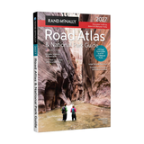
2026 Rand McNally Road Atlas & National Park Guide
Selling Fast!
40
people are looking at this
$29.95
$39.95
SAVE
$10.00
Complete 2026 road atlas
378 inset maps + mileage chart
Built for the open road
Frequently bought together
 2026 Rand McNally Road Atlas & National Park Guide
 High Protein Cookbook: 124 Easy Low-Carb Recipes + 30-Day Meal Plan
30-day money-back guarantee
Free shipping on all orders
⭐
Physical Book
Ships to your door
🏆
Ships in 7–13 Business Days
Free shipping on all orders
✨
30-Day Money-Back Guarantee
Not for you? Send it back

2026 Rand McNally Road Atlas & National Park Guide
What People Are Saying
Joy of the spiral-bound atlas
Oh the joy this brings me! I used to spend hours going over every page of the atlas book when I was a kid. Now I get to enjoy that feeling again with a spiral bound version (even better than when I was a kid!) And with the addition of the National Parks section, this will replace multiple journals/books! I love this more than I should!
Fabulous map of the United States
This is a fabulous map of the United States. It not only gives you directions how to get to certain places, but it highlights our National Parks and gives you a lot of information. So you can go and stay there and see the beauty of each national park. I love this beautiful map.
Physical map when signal drops
Love this! I absolutely love having a physical map just in case my phone loses its signal. The information on each National Park is great to have, too. This road atlas has already come in handy for planning a 12 day road trip from Indiana to Yellowstone National Park and back.
Editorial Leads. Maps Follow.
The 2026 Rand McNally Road Atlas & National Park Guide pairs a 132-page park guide (scenic drives, trails, lodges, natural wonders) with the complete 2026 Rand McNally road atlas — culinary road trips, Atlas Obscura highlights, Route 66 centennial features, and America's 250th planning angles. QR codes on editorial itineraries and state maps link to deeper on-road context. Updated annually by Rand McNally's Chicago cartography team; designed and printed in the USA.
What's Inside the Book Park by Park. State by State.
One spiral volume for park planning and open-road navigation — 63 national parks, 378 inset maps, and a complete North American road atlas.
What's Inside the Book Park by Park. State by State.
One spiral volume for park planning and open-road navigation — 63 national parks, 378 inset maps, and a complete North American road atlas.
63
National Parks
Full guide coverage — every U.S. national park
378
Inset Maps
Detailed city and park inset maps
133
Park Guide Pages
Dedicated national park editorial
379
Color Photos
Visual highlights across all parks
90
Cities on Mileage Chart
Distances between major cities and parks

How It Works Three Steps.
1
Pick Your Parks
Browse all 63 national parks with trails, scenic drives, lodges, and visitor tips
2
Map Your Route
Use state and province maps with construction, toll, and tourism resources
3
Hit the Road
Navigate with large-type highways, the 90-city mileage chart, and QR-linked itineraries
Is This Book For You?
- You plan cross-country trips and want one atlas that covers parks and highways
- You drive an RV or truck and need readable maps with construction and toll contacts
- You keep a paper backup when mountain passes and rural highways kill cell signal
- You are building a national park bucket list and want 2–4 pages per park, not half-page blurbs
- You are routing Route 66, America's 250th trips, or multi-state park loops this season
- You want Rand McNally's annually updated USA cartography in a lay-flat spiral binding
Why This Atlas BeatsTypical Road Atlases
See how this atlas compares on park coverage, inset maps, and USA-printed cartography.
Why This Atlas BeatsTypical Road Atlases
See how this atlas compares on park coverage, inset maps, and USA-printed cartography.
|
2026 Rand McNally Road Atlas
|
Typical Road Atlas
Limited park coverage
|
|
|---|---|---|
|
All 63 U.S. national parks
|
||
|
Park guide pages
|
||
|
378 detailed inset maps
|
||
|
Park maps 20–125% larger
|
||
|
2–4 pages per park + 379 photos
|
||
|
Updated annually, USA cartography
|
Our Promise
30-Day Money-Back Guarantee.
Every order is covered by a 30-day money-back guarantee from the day it arrives. If it's not the right fit, email us at calixstoresupport@gmail.com with your order number and we'll help you with a refund.
FAQ
What countries does this atlas cover?
+
United States, Canada, and Mexico. State and province maps include construction contacts, toll info, and tourism resources for on-road planning.
Does it include all 63 U.S. national parks?
+
Yes. The 132-page National Park Guide covers all 63 U.S. national parks with scenic drives, trails, lodges, photos, and visitor tips.
What is new in the 2026 edition?
+
Editorial leads. Maps follow. The 2026 edition adds culinary road trips, Atlas Obscura highlights, Route 66 centennial content, America's 250th planning angles, and QR codes on itineraries and state maps.
Is it spiral bound?
+
Yes. Spiral binding lets the atlas lay flat on your dashboard or picnic table while you plan routes and park stops.
What are the QR codes for?
+
QR codes on editorial road-trip itineraries and state map pages link to deeper on-road context — tourism sites, conditions, and trip planning resources.
Is this good for RV or truck routes?
+
Yes. Large-type highways, clearly labeled interstates and state routes, and a 90-city mileage chart support long-haul and cross-country routing.
How does this compare to other road atlases?
+
Most road atlases cover 24 parks with 14 park pages. This volume covers all 63 with 133 park pages, includes 378 inset maps, and is updated annually with USA-printed cartography.
Is this a physical book?
+
Yes — this is a physical, printed book shipped to your door. Full-color print.
How long does shipping take?
+
All orders typically arrive within 7–13 business days. Free shipping on all orders. Questions? calixstoresupport@gmail.com.
What if I don't like it?
+
Every order is covered by a 30-day money-back guarantee from the day it arrives. Email calixstoresupport@gmail.com with your order number.
How does the bundle offer work?
+
Order 2 or more books and receive a free digital ebook, added automatically at checkout. All orders ship free.